Tranquille River Trail – Kamloops Trails
A trail that follows the Tranquille River upstream to the canyon.
Driving Directions/Trailhead:
- Drive west on Tranquille Road, past the airport, the golf course, and ranches. When the road splits into two at Tranquille, take the upper road, cross the tracks and start the gravel road.
- Before the bridge across the Tranquille River, turn right and proceed to the parking area.
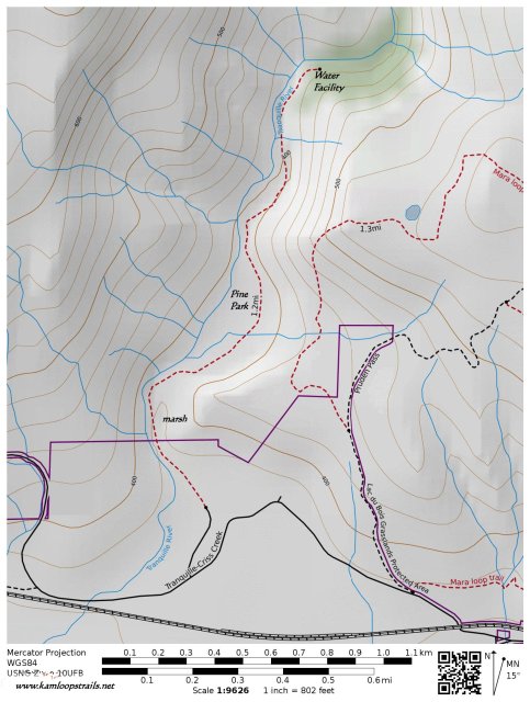
- The trail starts at the gate.
- The trail is a double track which winds parallel to the river. There are some single tracks that go to the river or into the hills.
- there is a marshy area at 0.3 km.
- Pine Park is at 1.1 km.
- The former water processing facility is at 2 km. Most people turn around at this point.
- From this point a rough single track winds up the canyon to a narrows.
- Along the route there are sometimes goldpanners, faces carved onto trees, birds and snakes, rapids on the river, a beaver area, and interesting flora and fauna, within Lac du Bois Protected Area.
Some Tranquille River Images:


More Information:
Doug Smith
Doug writes for Kamloops Trails, a not-for-profit (and ad free) website, offering information on trails, waterways, routes, featured spots, viewpoints, and explorations in the outdoors in the Kamloops area (and beyond).
Doug started exploring this area in 1976 and continues to follow tracks and routes wherever they lead, with the aid of map, compass, GPSr and camera. After many dead-ends, but also many discoveries, he chose to share this information.
The Kamloops Trails website has a massive number of interesting posts and would be of interest to anyone in Kamloops who enjoys the outdoors. Visit the Kamloops Trails website at: http://www.kamloopstrails.ca/
My Blog Posts