Opax Traverse – Kamloops Trails
Opax Mountain has a ring of lava cliffs overlooking valleys on the south, west, and northwest sides. Along the rim of these cliffs are open, rocky slopes with great viewpoints. They are all hard to get to, requiring a long approach route, good navigation, and some off-trail exploration. We followed a known route up to the plateau above, then worked our way out to the south-facing rim for a longer traverse to the east side of the mountain.
 We followed the good double track around Lac du Bois to Hanging Valley, then turned onto an overgrown track which wound up the mountain.
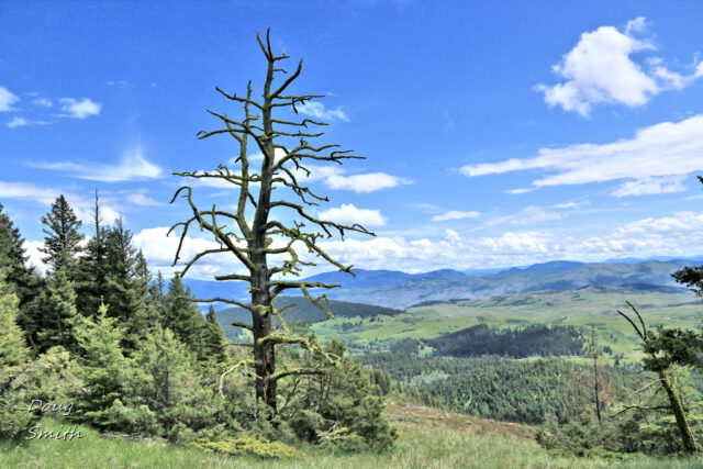
 The climb up to the top of the rim is about 4 km, climbing 570 m in elevation. At the west end Hanging Valley was below with Lac du Bois southeast.
 The lava cliffs rim area is a wet, rocky slope with many spring wildflowers, only a few of which are shared here.

agoseris |

chickweed |

sedum |

clematis |
We traversed east along the rim for 2 km to the end of the lava flow.
 Lac du Bois was directly south, but there was no easy way down. From there all routes are steeply downhill with no trails. We knew that there was a double track on the north side so we wound down steep slopes to the bottom of a creek valley and back up the other side to the double track which we call the East Opax Trail (from Mud Lake).
 The final part of the hike was to Mud Lake, then a turn south onto old tracks past grassland slopes and aspen groves to Lac du Bois.
 The ascent to the Opax Traverse is worth the effort. The whole route is 12+ km and will take about 4 hours.
 Next year we will be doing a traverse of the west rim, an even longer route.
Doug Smith
Doug writes for Kamloops Trails, a not-for-profit (and ad free) website, offering information on trails, waterways, routes, featured spots, viewpoints, and explorations in the outdoors in the Kamloops area (and beyond).
Doug started exploring this area in 1976 and continues to follow tracks and routes wherever they lead, with the aid of map, compass, GPSr and camera. After many dead-ends, but also many discoveries, he chose to share this information.
The Kamloops Trails website has a massive number of interesting posts and would be of interest to anyone in Kamloops who enjoys the outdoors. Visit the Kamloops Trails website at: http://www.kamloopstrails.ca/
My Blog Posts