On Mt. Thynne – Kamloops Trails
When we drive south we follow the Coldwater River into the Coquihalla Summit area which has many steep, rocky peaks, mostly still covered in snow in June. On the east side of the river are more rounded mountains, mostly forested and lower. Mt. Thynne is a higher ridge-shaped mountain that lies between the rugged peaks of the Coquihalla and the Interior Plateau. The shape of the mountain makes good hiking with a long subalpine ridge from the trailhead to the summit. We try to time our hike after enough snow melts at 1900+ m (6230+ ft), but before the ATV crowds arrive on dry tracks. Near the end of June we drove to Brookmere, then up a maze of mountain forest service roads (for 16 km) to the trailhead.
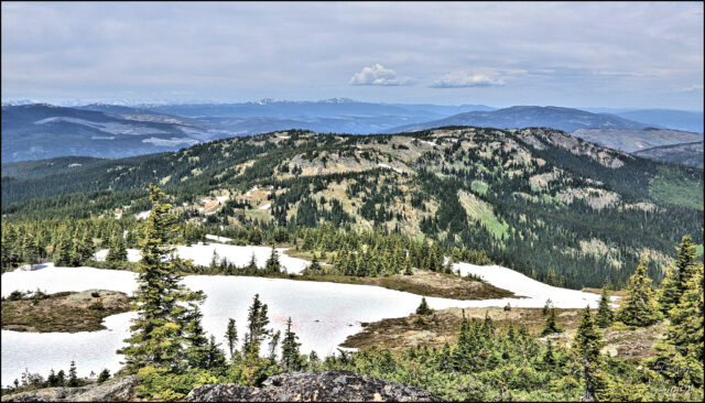
Our hike was 11 km return on double tracks to the summit and back. The ridge/spine of Mt. Thynne can be seen in this photo.
Along the track were many wildflowers, tarns, and wet areas.
 The hike took us 4 hours (inc. lunch). The route has more ups than downs on the way out, but the ridge hike requires lots of up and down hiking.
From the ridge we had fine views to the Coquihalla. Guanaco and Vicuna Peaks (we have hiked those too) were 16 km away to the southwest.
 Coquihalla Mountain, Jim Kelly Peak, and Illal Meadows were 22 km to the south. We will be in that area again in September.
 There were blue-sky-views of Yak Peak, Zoa, Zopkios Ridge, Needle Peak, July Mountain, and other peaks of the Coquihalla Summit and the Anderson Range. In the distance we could see Mt. Baker.
Mt. Thynne is a favorite for a number of reasons. We will have 360 degree views, but it is the views to the west and the south that are inspiring. We get to hike on a good trail through open subalpine meadows, with tarns, snow drifts, and spring-like plant growth. And, one of the best wildflower displays in the province is along the side of the trail for the whole distance. A few wildflower images are provided here:

Doug Smith
Doug writes for Kamloops Trails, a not-for-profit (and ad free) website, offering information on trails, waterways, routes, featured spots, viewpoints, and explorations in the outdoors in the Kamloops area (and beyond).
Doug started exploring this area in 1976 and continues to follow tracks and routes wherever they lead, with the aid of map, compass, GPSr and camera. After many dead-ends, but also many discoveries, he chose to share this information.
The Kamloops Trails website has a massive number of interesting posts and would be of interest to anyone in Kamloops who enjoys the outdoors. Visit the Kamloops Trails website at: http://www.kamloopstrails.ca/
My Blog Posts