Middle Grasslands Kettles and Eskers
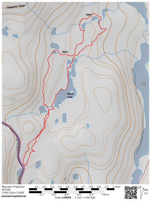
At the end of fall as snows started to blanket the hills I ventured into the upper middle grasslands to hike along various glaciated features, including pothole lakes, eskers, kames, moraine ridges, and erratics. Since the last Ice Age, erosion has also deepened drainage gullies, some ponds were filled with run-off silts, and melt-freeze cycles have broken rocks, boulders, and outcrops. The route I hiked followed many of these geographic features. From a parking area off the Lac du Bois Road I followed a single track as it wound through hills into a basin area to the northeast. Meltwater and rain run-off fills the bottom of the basin forming Island Lake and a few more ponds. I hiked off-trail on snow around the west side of the lake.
There are only a few single trees in the whole area and the elevation is above the sagebrush of the lower and middle grasslands. Grassland ridges, hillocks, and slopes surround the ponds and lakes.
 At the north end of Island Lake is the Grasslands Esker winding from Lac du Bois down to Long Lake, a distance of over 2 km and a drop of 150 m. Eskers are the sinuous ridges left behind from an under-ice glacial stream or a stream channel on the glacier.
 I crested the esker then continued north following moraine ridges and kames. Long Lake filled the bottom of the valley below.
 I was exploring to find a second esker which was not far away. The esker wound down from the shoulders of Clapperton Ridge, leaving a curved ridge halfway down the slope.
 I hiked up the second esker then started to loop back, investigating pothole ponds (kettles) at the foot of the slopes.
 These kinds of landforms are sometimes called kettle and kame topography.
 In spring and summer we can see ducks, muskrats and grassland birds in the ponds and lakes. Long billed curlews (link) and grouse may be spotted. Coyotes, voles, mice, and marmots frequent the grasslands.
 My kettles-and-kames route returned on a route above Island Lake.
 The hike was about 6 km taking over two hours. I will be returning in spring for the wildflowers, the waterfowl, and spring renewal.

Doug Smith
Doug writes for Kamloops Trails, a not-for-profit (and ad free) website, offering information on trails, waterways, routes, featured spots, viewpoints, and explorations in the outdoors in the Kamloops area (and beyond).
Doug started exploring this area in 1976 and continues to follow tracks and routes wherever they lead, with the aid of map, compass, GPSr and camera. After many dead-ends, but also many discoveries, he chose to share this information.
The Kamloops Trails website has a massive number of interesting posts and would be of interest to anyone in Kamloops who enjoys the outdoors. Visit the Kamloops Trails website at: http://www.kamloopstrails.ca/
My Blog Posts