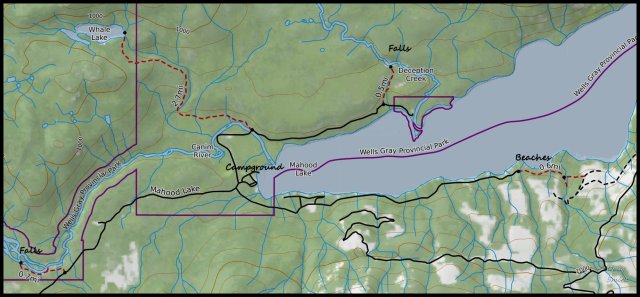
Mahood Lake Trails – Kamloops Trails
From a basecamp at Mahood Lake Provincial Park there are several opportunities to hike short routes nearby.
Canim Falls and Mahood Falls
The trail to Canim and Mahood Falls is 4.5 km west of the campground. A good trail leads to viewpoints of the falls.

The falls flow over a lava dike which flowed over the Canim River Valley.
 At various times of the year it appears as two falls or sometimes three, both on the Canim River which splits into two channels. The trail is short to the falls, but views are limited and to get closer to the falls and have unimpeded views, some scrambling is required.

South Beaches
The South Mahood Road continues down the lake as access to several seasonal homes. The road continues for another 4 km but is not really suitable for regular vehicles. The road can be hiked or biked to the South Beaches.
 There are some tracks to explore and some gravel beaches near the end of the road.
 We drove as far as we could, then walked down to the end and back.

Deception Falls
A road goes around the north side of the road and ends at some private lands, but along the way is the signed Deception Falls Trail. The trail is less than 1 km in length climbing gradually through deciduous forests. Windfall is often encountered on the trail.
 Deception Falls is a 30m falls, but the viewpoint is set back a ways. I hiked up the trail to get a viewpoint down the falls, but I was hoping for a view from the bottom. there appeared to be a rough route down, but it was a scramble and quite wet.

Other Trails
There is a 2 km trail along the Canim River that led to some old homesteads, but the trail was overgrown and damp.
 Another option is to hike the Whale Lake Trail, a forested hike to a small lake. The Camping Canucks provide a good post on this hike.
The East End of Mahood Lake
We have paddled the length of Mahood Lake (21 km) and camped at the campsite near the Mahood River. The Mahood River Trail starts on the south side of the Mahood River and goes down to Sylvia and Goodwin Falls:
Doug Smith
Doug writes for Kamloops Trails, a not-for-profit (and ad free) website, offering information on trails, waterways, routes, featured spots, viewpoints, and explorations in the outdoors in the Kamloops area (and beyond).
Doug started exploring this area in 1976 and continues to follow tracks and routes wherever they lead, with the aid of map, compass, GPSr and camera. After many dead-ends, but also many discoveries, he chose to share this information.
The Kamloops Trails website has a massive number of interesting posts and would be of interest to anyone in Kamloops who enjoys the outdoors. Visit the Kamloops Trails website at: http://www.kamloopstrails.ca/
My Blog Posts