Hiking through the Frederick Bluffs
We hike through the Frederick Bluffs twice every year. There are no trails and the whole area is rugged, but there is interesting terrain to explore and wonderful viewpoints along the way. We drive out the Frederick Road and we turn onto the lower road. We park to the left side of the road before the road starts to drop down to the lake. Our route is usually counter clockwise, winding over hills and through gullies, working our way out to the last bluff overlooking Frederick. Along the way are rocky bluffs, grassland slopes and a few old snags.
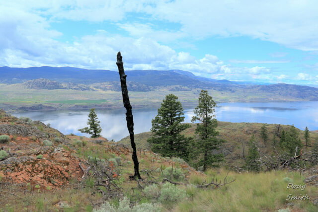
 A few charred trees stand on slopes, this one next to an old glacial erratic, moved here from the foot of the Red Plateau Escarpment.
 Our route usually goes across the hilltops requiring some route finding to avoid cliffs and loose rock. There are few ponds in the hollows between hills.
 From the west end of the loop we can see down Kamloops Lake to Six Mile Point.
 The Dewdrop Range continues along the benchland above Kamloops Lake to Rousseau Hill, an extension of Red Plateau.
 Across the lake are the green benchlands near Tobiano.
 The loop route going east requires going up over rocky hills to Bighorn Bluff. Kamloops Lake lies in the Thompson River Valley below rocky hills on both sides.
 We usually stop for lunch on Bighorn Bluff, with views up and down the lake
 Bighorn Bluff is the last rocky hill rising above the lake before Battle Bluff, seen here, 3 km east.
 Our loop in the hills was 5.4 km. On our way back, we stopped to enjoy the Red Plateau Escarpment, rising above the dewdrop Range. We will be climbing the escarpment in the next week.
 Any hiking in the Frederick Bluffs is an exploration since there are no trails. Make up your own route and enjoy the rugged terrain on the edge of the Dewdrop Range.
Doug Smith
Doug writes for Kamloops Trails, a not-for-profit (and ad free) website, offering information on trails, waterways, routes, featured spots, viewpoints, and explorations in the outdoors in the Kamloops area (and beyond).
Doug started exploring this area in 1976 and continues to follow tracks and routes wherever they lead, with the aid of map, compass, GPSr and camera. After many dead-ends, but also many discoveries, he chose to share this information.
The Kamloops Trails website has a massive number of interesting posts and would be of interest to anyone in Kamloops who enjoys the outdoors. Visit the Kamloops Trails website at: http://www.kamloopstrails.ca/
My Blog Posts