Hiking Sugarloaf Mountain in the Lundbom Commonage
The Lundbom Commonage Reserve area is one of our favorite places to hike in the spring. The grasslands hills are some of the finest in the province and the multi-use trails are pleasant to hike, although some navigation is almost always required. One of the easiest-to-follow trails is the double track from Lundbom Lake to the top of Sugarloaf Mountain.
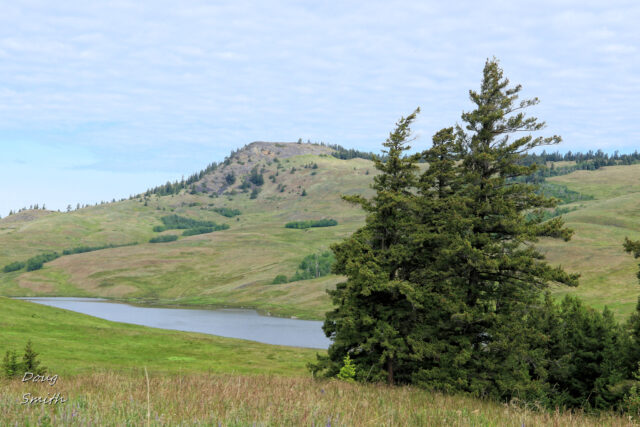
 The summit area can be clearly seen from 3 km away on a ridge west of Lundbom Lake.
 Double tracks lead over to Hamilton Lake. From the lakeshore a track climbs the east slope of the mountain.
 There is a light scramble to get to the top, where there are wide views down to Hamilton Lake, and back to where we parked, near Lundbom Lake.
 The rolling hills of the Commonage to the northeast invite more exploration. We have hiked the Wounded Knee Trail and the Cocobonk Trail over in that area, scribing longer clockwise loops through the hills.
 In the distance to the southwest Stoyama Mountain and Mount Hewitt Bostock in the North Cascades were still mantled in snow, 42 km away.
 We found a route down the north end of Sugarloaf Mountain, then followed single tracks around the back side over to an established trail which looped down the flanks of Sugarloaf and then back down to Hamilton Lake.
On the way down I was pleased to find Idaho blue-eyed grass (sisyrinchium idahoense sp.) in flower. It is in the iris family and is not (normally) seen in the Kamloops area.
 This moderate hike is about 8.5 km in length, taking about 2.5 hours. It is rewarding trip for a day of hiking in the Lundbom Commonage Reserve.
Doug Smith
Doug writes for Kamloops Trails, a not-for-profit (and ad free) website, offering information on trails, waterways, routes, featured spots, viewpoints, and explorations in the outdoors in the Kamloops area (and beyond).
Doug started exploring this area in 1976 and continues to follow tracks and routes wherever they lead, with the aid of map, compass, GPSr and camera. After many dead-ends, but also many discoveries, he chose to share this information.
The Kamloops Trails website has a massive number of interesting posts and would be of interest to anyone in Kamloops who enjoys the outdoors. Visit the Kamloops Trails website at: http://www.kamloopstrails.ca/
My Blog Posts