Hiking Mt. Thynne – Kamloops Trails
Mt. Thynne is a rounded, open mountain just 145 km from the Coquihalla Summit area. Because of its elevation (2256 m), location, and shape, snows clear off the access road and the summit ridge relatively early so we can do a summit hike in June. In 2020, the snows were slow to melt so we rescheduled our hike until the end of the month. The access road (16 km) from Brookmere (Lower McPhail, Thynne Mountain Road, Upper McPhail Road) was fine, though it is slow-going for some sections and high clearance near the top We parked at the snowmobile cabin and hiked up the double track. The summit of the mountain is 5.75 km south. The first part of the hike climbs 200m over 2.0 km, then the route goes up and down to the final hill.
 The middle section of the Mt. Thynne route is a double track through subalpine meadows with a number of tarns, wide views, and lots of seasonal wildflowers.
 There were many varieties of wildflowers along the route, but the star of the day was western pasqueflower.

From the open ridge, many of the Coquihalla Summit peaks were on show. A favorite hike is July Mountain, just 11 km west.
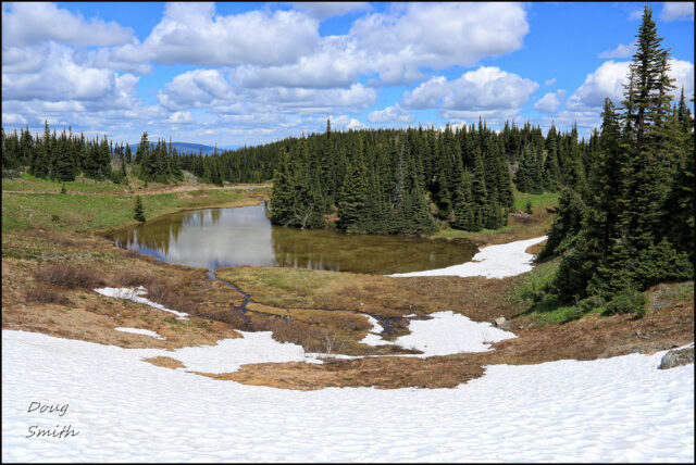
 There were a number of banks of snow in sheltered spots and near the summit. Those on the west side of this tarn were wind drifts blown over the ridge to the leeward side of the ridge.
 The Coquihalla Summit peaks rise above the lower peaks of the area 18 km southwest.
 The subalpine meadows next to the double track featured some snow, some wildflowers in meadows, and some high-level stunted forest groves.
 Some of the mountains we have hiked were still snow-mantled. In this photo (left to right) stood Needle, Thar, Nak, Yak, and lower on the right, Zoa Peak.
 We hiked out and back on the same track (11.5 km total) on a fine day. There were some mosquitoes, but mostly in sheltered areas, away from the wind. We prefer to go to Thynne in the early season before the arrival of quads, 4×4’s, and motorcycles, but also when the higher alpine peaks are still snowed in.

This hike makes for a long day. We drove from Kamloops to Brookmere, then up the mountain road (we took one wrong turn and had to backtrack), hiked the mountain, and returned, an all-day adventure in remote country. We will be back next year in June.
More Information:
Doug Smith
Doug writes for Kamloops Trails, a not-for-profit (and ad free) website, offering information on trails, waterways, routes, featured spots, viewpoints, and explorations in the outdoors in the Kamloops area (and beyond).
Doug started exploring this area in 1976 and continues to follow tracks and routes wherever they lead, with the aid of map, compass, GPSr and camera. After many dead-ends, but also many discoveries, he chose to share this information.
The Kamloops Trails website has a massive number of interesting posts and would be of interest to anyone in Kamloops who enjoys the outdoors. Visit the Kamloops Trails website at: http://www.kamloopstrails.ca/
My Blog Posts