Frosty Mountain – Kamloops Trails
Frosty Mountain stands at 2408 m (about 7900 feet) just one kilometer north of the US border in Manning Park. The trail to the summit of Frosty starts at the Lightning Lake Day Use area.
 For the first 3 km, the trail switchbacks above the lake through the forest, gaining altitude steadily.
 Frosty Creek Camp is an open-forested area at 6.8 km.
 A grey jay stopped to visit us at the campsite.
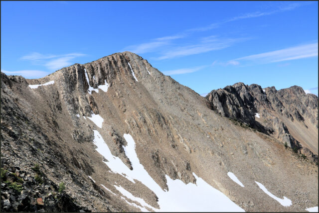
 Above the campground we entered a larch subalpine forest with moderate elevation gains, the best part of the trail. Frosty is seen here 2 km to the south standing above the ridge.
 As we climbed up the approach ridge, the rugged slopes of the Frosty-area border peaks flanked our route.
 Snow remained in the north-aspect cirque as we climbed on loose rock to the summit ridge.
 The final section is on loose rock material, zigzagging up to the summit ridge, followed by a traverse over to the final ascent.
 From the top, mountains stretch in every direction. The tallest peaks were to the south. We could also see Lightning Lake far below.
 Hozomeen Mountain stood just across the border to the west, rising with horn-shaped peaks above Ross Lake.
 We returned the way we came, dropping down the talus slopes to the trail on the approach ridge.
 The trail descended back into the open larch forest.
 From the meadow glades of the larch forest, we continued down into the forest.
 We could see down to Lightning Lake, but also west to Flash Lake. Strike and Thunder Lakes were out of sight farther west.
 We found the trail to be long, hot, and tiring, taking all day this time. We had done this hike before, but decades earlier. It seems to get harder each time, but we will probably forget and do it again… (we love the Mt. Frosty hike).
Directions to the Trail:
- Drive on Highway 3 to Manning Park
- Turn south at Manning Park Lodge and follow the road toward the ski hill (Gibson Pass Road), the same road as the one to the Lightning Lake Campground)
- At about 3 km, a signed turn on the left leads down to the Lightning Lake Day Use area
- Park there. Follow a trail around the east end of the lake, crossing the dam.
- 200m along the trail is the signed trailhead for Frosty Mountain. The rest of the trail is signed all the way to the top.

Doug Smith
Doug writes for Kamloops Trails, a not-for-profit (and ad free) website, offering information on trails, waterways, routes, featured spots, viewpoints, and explorations in the outdoors in the Kamloops area (and beyond).
Doug started exploring this area in 1976 and continues to follow tracks and routes wherever they lead, with the aid of map, compass, GPSr and camera. After many dead-ends, but also many discoveries, he chose to share this information.
The Kamloops Trails website has a massive number of interesting posts and would be of interest to anyone in Kamloops who enjoys the outdoors. Visit the Kamloops Trails website at: http://www.kamloopstrails.ca/
My Blog Posts