Dam Lake, Thickets Meadows, and Spade Lake
The Outer Inks Trail system is a wide area of forested routes on the lower slopes of Chuwhels and Greenstone Mountain. The Coquihalla Highway is the eastern border. There are a few roads and a lot of ATV tracks. Many of the single and double tracks provide good hiking, especially in the off-season for motorized vehicles. Some of the tracks are signed by the Greater Kamloops Motorcycle Association, but the trails are unofficial, though still used. I don’t hike there from late spring through summer, especially on weekends. I prefer the quieter times of early spring, fall, and winter. On this last late April day, there was no one else on the trails on a 9.6 km route.
From the main parking area on the Inks Lake Road, I turned up the hill to follow single tracks through the open forest.
 My first destination for the day was Dam Lake. The lake was full and spilling its banks over a double track. It was draining in a cascade into Alkali Creek.
 When the lake is full a small island is surrounded by the lake water. By late summer, it will just be a point sticking into the lake.
 From Dam Lake I worked my way west to a marsh and meadow on the Thickets Trail, and from there down to Spade Lake.

I spotted a coyote, a couple of deer, ducks and geese, and many birds along the way.
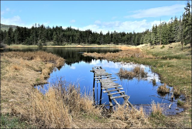
Next to Spade Lake is a marshy lake full of waterfowl, toads, and pond life. 
This lovely, but remote spot is a favorite that I try to hike to at least once a year. It is 3.5 km from the parking area.
 On the way back the slopes of Sugarloaf Hill were lighted by the sun’s rays shining through intermittent cloud.
 The hike took 2 3/4 hours. It was quiet the whole way allowing for a time of moving meditation in the open forests of the Outer Inks Trails.

Doug Smith
Doug writes for Kamloops Trails, a not-for-profit (and ad free) website, offering information on trails, waterways, routes, featured spots, viewpoints, and explorations in the outdoors in the Kamloops area (and beyond).
Doug started exploring this area in 1976 and continues to follow tracks and routes wherever they lead, with the aid of map, compass, GPSr and camera. After many dead-ends, but also many discoveries, he chose to share this information.
The Kamloops Trails website has a massive number of interesting posts and would be of interest to anyone in Kamloops who enjoys the outdoors. Visit the Kamloops Trails website at: http://www.kamloopstrails.ca/
My Blog Posts