Clapperton Hill Traverse – Kamloops Trails
Clapperton Hill is the forested ridge-hill that rises above the grasslands in the Lac du Bois Nature Conservancy. In past years I have hiked and snowshoed around the hill, I had climbed to the top area from the southwest, and I have visited a favorite viewpoint on the south shoulder a number of times. On this November day, the plan was to traverse the ridges, hills, and gullies from east to west.
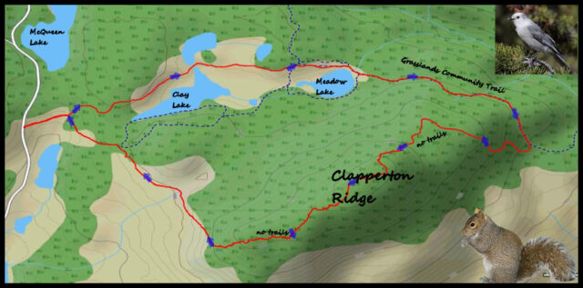
The route started on a grassland track at the edge of the forest.
 In less than a kilometer the hike went along the north shoreline of Clay Lake.

Continuing east to the Grasslands Community Trail, the hike passed Meadow Lake.
 The Grasslands Community Trail starts on the Isobel Lake Road, but I intersected it south of the trailhead closer to Meadow Lake, then I continued east, then southeast around the flank of Clapperton Hill. At an eclectic point, I turned and started climbing up the hill, following whichever route offered the least resistance. It was steep and there were a series of hills and gullies to wind up and down over 2.6 kilometers. At the top of each hill, the forest was more open and brighter.
 The upper reaches of the hills had a bit of snow in protected areas in the douglas fir forest. The way up to the top was difficult with many fallen trees and debris, slow progress at best. Anyone trying this hike must be willing to fight through the thick areas. At the top were no viewpoints so the reward is walking through the open forest on top.
 I came down steep slopes on the west side of Clapperton Hill. The upper parts were more difficult with many “rock and roll” hazards. The lower sections were pinegrass slopes, steep, but easy hiking. I returned to a known track through the upper grasslands, passing a partly-frozen marsh.
 A squall blew through the area and ominous clouds continued to the east.
 The Clapperton Hill Traverse is not a recommended hike because it has a long difficult section and no viewpoints to offset the challenges. Why do it then? … Because it is there and someone needed to do it.

Doug Smith
Doug writes for Kamloops Trails, a not-for-profit (and ad free) website, offering information on trails, waterways, routes, featured spots, viewpoints, and explorations in the outdoors in the Kamloops area (and beyond).
Doug started exploring this area in 1976 and continues to follow tracks and routes wherever they lead, with the aid of map, compass, GPSr and camera. After many dead-ends, but also many discoveries, he chose to share this information.
The Kamloops Trails website has a massive number of interesting posts and would be of interest to anyone in Kamloops who enjoys the outdoors. Visit the Kamloops Trails website at: http://www.kamloopstrails.ca/
My Blog Posts