Chuwhels Mountain Hike – Kamloops Trails
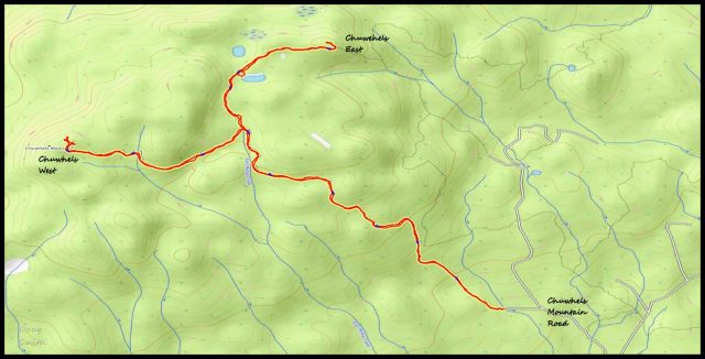
Chuwhels Mountain is the highest point in the hills to the south of Kamloops. The summit is at 1891m (6204 ft). It is a sprawling, forested mountain with lots of cutblocks, and a number of forest service branch roads. There is a good forest service road that turns off the Lac le Jeune Road and goes to Lodgepole Lake. The road is in fairly good shape for another 4.5 km, requiring high clearance, but not four wheel drive. We had planned to drive to an easy-to-miss junction (at N50 31.715 W129 33.248). We parked off the side of the road at that point and we noted that the road was quite a bit rougher after we had parked.
From the right fork (note the photo below), we hiked up the double track for 2.65 km.

We took the right fork to go to the secondary summit, passing a marshy pond. We arrived at the northern summit after hiking 1.2 km. Workers were there doing geological surveys. There was a generator, a large drone, and various types equipment at the top, so we looked around and turned back down the track to the junction.

From the north summit, we had wide views to the northeast and northwest, but it was a hazy/smoky day.

We then hiked for 1.4 km on the left fork to the true summit which is topped with communications towers. There were better views, including over to the south side of Greenstone Mountain (1779 m).

Although I had been to the top of Chuwhels Mountain three times before, it was the first time hiking from the lower point. We had skied up, snowshoed most of the way up, and had driven to the upper junction with 4WD to start the hike. There are no remarkable sights on the mountain, but it is a good hike for a nice day.
Doug Smith
Doug writes for Kamloops Trails, a not-for-profit (and ad free) website, offering information on trails, waterways, routes, featured spots, viewpoints, and explorations in the outdoors in the Kamloops area (and beyond).
Doug started exploring this area in 1976 and continues to follow tracks and routes wherever they lead, with the aid of map, compass, GPSr and camera. After many dead-ends, but also many discoveries, he chose to share this information.
The Kamloops Trails website has a massive number of interesting posts and would be of interest to anyone in Kamloops who enjoys the outdoors. Visit the Kamloops Trails website at: http://www.kamloopstrails.ca/
My Blog Posts