Central Mountain Trail (Murtle Lake)
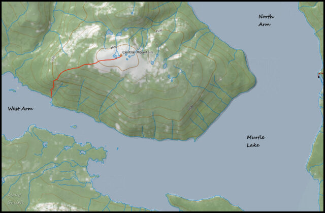
To get to Murtle Lake, we have to drive to Blue River, then drive up into the mountains for 23 km. At the trailhead we have to load the kayaks onto carts and portage for 2.5 km. At the boat launch on Murtle Lagoon, we then paddle for 12 to 14 km to camp at a marine campsite. On this trip to Murtle Lake, we camped on Leo Island. On this particular trip, I did a solo paddle and hike to Central Mountain. I paddled 1.5 km to the trailhead at a sign on the shoreline. There wasn’t much of a landing so I hauled my kayak up the rocky shoreline, then put on my hiking boots.
The forested trail was steep and grown-over in some sections. It is not hiked much so the trail is indistinct so some navigation was required.
The hike to the top of the mountain is 7.5 km. Near the top I passed through a subalpine meadow with views down the West Arm of Murtle Lake. Bears frequent the area so I made noise on the way up. The open meadows on top are part of a caribou migration route, but I didn’t spot any.
 The alpine area was open with meadows and rock outcrops, and wide views.
 From the southern edge of the summit. I could see down to Leo Island below, our marine campsite.
 From the summit, I chose to continue east to the edge of the slope break to see if I could see down to the lake.
 From a viewpoint the North Arm of Murtle Lake was below, with the Wavy Range above, on the east side.
 I continued farther north and came to a viewpoint of the north end of the North Arm of Murtle Lake. The Murtle River drains into the lake from the Cariboo Mountains in Northern Wells Gray Park.
 This turned out to be a long day of hiking. The return hike is 15 km, but I added more distance by traversing across the top of the mountain east, then north.
The hike is really only for experienced backcountry hikers who can navigate and be self-sufficient. It is not a hike I will do again, but I am happy to have done it this day. A Google EArth Fly-Over is shared here for an overview of Central Mountain.

Doug Smith
Doug writes for Kamloops Trails, a not-for-profit (and ad free) website, offering information on trails, waterways, routes, featured spots, viewpoints, and explorations in the outdoors in the Kamloops area (and beyond).
Doug started exploring this area in 1976 and continues to follow tracks and routes wherever they lead, with the aid of map, compass, GPSr and camera. After many dead-ends, but also many discoveries, he chose to share this information.
The Kamloops Trails website has a massive number of interesting posts and would be of interest to anyone in Kamloops who enjoys the outdoors. Visit the Kamloops Trails website at: http://www.kamloopstrails.ca/
My Blog Posts