Zupjok Peak Trail – Kamloops Trails
In a summer of smoke, I looked for a day to hike to the top of one of the Coquihalla Summit Peaks. Since I had done Yak, Needle, Flatiron, Zoa, and Illal in the last 2-3 years, I decided to return to do Zupjok Peak, a favorite. When I first started exploring Ottomite Mountain, Iago Peak, and Zupjok Peak, there was a good trail to Ottomite, but we had to make our own route after that. Each time I return, the trail is better and better and on this day in July, the trail was very clear and in good shape.
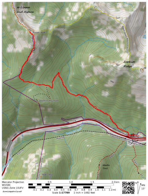
A double track starts on the west end of the Zopkios Ridge Rest Area. The double track winds up through the forest to Ottomite Mountain, a forested, rounded hill.
 I used to have to watch carefully for the turn to cross the meadows between Ottomite and Zupjok, but now there is a large cairn and a well-defined trail.

The single track crosses the meadows for 0.75 km, then starts a 1.2 km steep ascent up the south-facing ridge of Zupjok.
 The summit provided fine views in every direction. To the east was Zopkios Ridge with Yak, Nak, and Thar Peaks lined up.
 To the north was the ridge hike to Llama and Alpaca Peaks, a much longer day hike (it would be a good overnight route). Beyond were Vicuna and Guanaco Peaks. We have hiked to the top of Guanaco three times in past years.
 To the northwest were the Anderson Peaks (Reh, Serna, Gemse, Gemuza, Steinbok, Ibex, and Chamois). They are accessed by the Anderson River FSR, on 25 km of backroads from the Fraser River near Spuzzum.
 To the south was Flatiron Mountain. We could also see Needle Peak, but we were looking directly into the sun at that point. By exploring the summit area we could see over to Iago Peak (2.6 km away) and Great Bear Peak. We have done Iago Peak three times too.
 We returned the way we came. As we descended Ottomite Mountain, Yak Peak stood high above the ridges.
 On a hot day, I enjoyed the cooler forest for the final 2 km and we also stopped to wade into Zopkios Stream before finishing our hike.
 The return hike to Zupjok Peak and back was about 12 km, about 4 hours of hiking. The steep pitch up the ridge was more difficult, but overall this is a fine hike for a summer day. I hope to return to snowshoe up Ottomite Mountain, or perhaps over to Iago Peak this winter.
More information:

Doug Smith
Doug writes for Kamloops Trails, a not-for-profit (and ad free) website, offering information on trails, waterways, routes, featured spots, viewpoints, and explorations in the outdoors in the Kamloops area (and beyond).
Doug started exploring this area in 1976 and continues to follow tracks and routes wherever they lead, with the aid of map, compass, GPSr and camera. After many dead-ends, but also many discoveries, he chose to share this information.
The Kamloops Trails website has a massive number of interesting posts and would be of interest to anyone in Kamloops who enjoys the outdoors. Visit the Kamloops Trails website at: http://www.kamloopstrails.ca/
My Blog Posts