Though the Barren Hills in the Fog
In late fall most of the trails of the area became quite icy so we decided to hike in the lower grasslands on a route I call the Barren Hills. It is just an section of the lower Batchelor Hills. Some of the old double tracks were used by ranchers. Most of the single tracks are relatively new, made by mountain bikers. They have named these new single tracks which can be best seen on Trailforks. The trailhead we started from is off a short side road just past Batchelor Hill. About 0.7 km up the double track is a signed junction. We took the right fork following the Bighorn Trail.
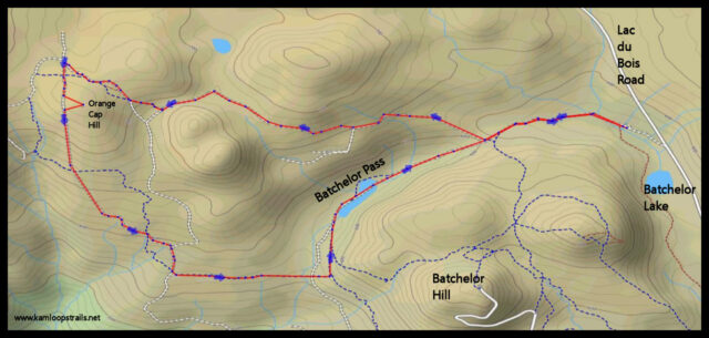
Our hike took us over Orange Cap Hill where there is a wide view of the grasslands. On this foggy day only the hills nearby were visible.
 To do a loop route that moderated some of the up-and-down we took the Kow a Been Here Trail (a new trail that parallels the old double track we used to use). It winds through Batchelor Pass which is usually quite wet in spring. A seasonal pond fills the low spot but it dries in the summer.

The tracks wind through the moraine hills. A few single tracks go straight up the hills but the double tracks and a few of the single tracks take a more gentle route allowing a moderate 7.6 km loop.
 At the trailhead are a number of tall grasses. Many of these in a riparian zone on the shores of Batchelor Lake. This was a year-round lake some decades ago, but it has been gradually filled in with silts from run-off and has turned into a wet meadow now.

We have been hiking the Barren Hills for over 40 years. It has stayed somewhat the same, but it is better now that motorized vehicles are no longer tearing up in the hills. My thanks to BC Parks for preserving the natural state of the lower grasslands.

Doug Smith
Doug writes for Kamloops Trails, a not-for-profit (and ad free) website, offering information on trails, waterways, routes, featured spots, viewpoints, and explorations in the outdoors in the Kamloops area (and beyond).
Doug started exploring this area in 1976 and continues to follow tracks and routes wherever they lead, with the aid of map, compass, GPSr and camera. After many dead-ends, but also many discoveries, he chose to share this information.
The Kamloops Trails website has a massive number of interesting posts and would be of interest to anyone in Kamloops who enjoys the outdoors. Visit the Kamloops Trails website at: http://www.kamloopstrails.ca/
My Blog Posts