The Route to Castle Butte in Summer
Castle Butte is a rocky ridge with a steep bluff jutting out above the Dewdrop – Red Plateau Escarpment. There is no trail to the airy spot, but a faint route can be followed from the Dewdrop Trail. We can hike up the Dewdrop Trail from the Dewdrop Range far below for a demanding 5.8 km route (one way) with an elevation gain of 700m (2300 feet) or we can instead come across Red Plateau for an easier 7 km return route. Some navigation is required and some route finding is an asset to find the best way to Castle Butte.
From the Tranquille Criss Creek Road, turn left onto the Red Plateau Forest Service Road (the turn is opposite at the Pimple parking area). This backroad is best driven in dry conditions. It is narrow in spots and high clearance is recommended It climbs through the hills, then levels off in the forest on top of Red Plateau. Follow the road until you pass the 4.5 km mark. On the right is a parking area and on the left is an old secondary double track angling southeast. Follow the track through the forest until you reach another backroad junction, then turn right. Follow that road for 1 km as it climbs gradually. Just past a pond, another side road on the left turns south. A BC Parks sign is there to confirm the route choice. Follow that track until it meets the Dewdrop Trail at the Rim. Continue along the Dewdrop Trail bearing west as it goes up and down. As the route climbs onto an open ridge, veer off for the view and to orient yourself. To the right is Mushroom Rock, a distinctive hoodoo. To the west are the red-coloured cliffs of the Red Plateau Escarpment. Directly south is Castle Butte, partly hidden by forest cover. Follow a rough track down the ridge. As the ridge narrows, the route arrives at steep bluffs, the north cliffs of Castle Butte, Turn around to the left side staying on narrow ledges (don’t drop into the gully). After some careful hiking you will arrive at a spot where some scrambling is required. It is only a 40 vertical foot climb and there are many small ledges and handholds. Carefully climb the rocky wall and go to the top of the knoll. Continue south to the open views on Castle Butte. Stay back from the drop-offs to enjoy the wide views.

From the Castle Butte viewpoint, the reddish cliffs of the Escarpment extend to the west.
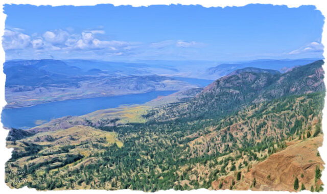
 The Dewdrop Range continues west for a few kilometers on a rocky benchland above Kamloops Lake.
 We could also seen east to the Thompson River Valley, but haze/mill smog filled the valley that day. On the Castle Butte ridge we were pleased to spot a nighthawk.
 We returned the way we came, completing a pleasant 7 km hike through the forest on a warm summer day.
More Information:
Doug Smith
Doug writes for Kamloops Trails, a not-for-profit (and ad free) website, offering information on trails, waterways, routes, featured spots, viewpoints, and explorations in the outdoors in the Kamloops area (and beyond).
Doug started exploring this area in 1976 and continues to follow tracks and routes wherever they lead, with the aid of map, compass, GPSr and camera. After many dead-ends, but also many discoveries, he chose to share this information.
The Kamloops Trails website has a massive number of interesting posts and would be of interest to anyone in Kamloops who enjoys the outdoors. Visit the Kamloops Trails website at: http://www.kamloopstrails.ca/
My Blog Posts