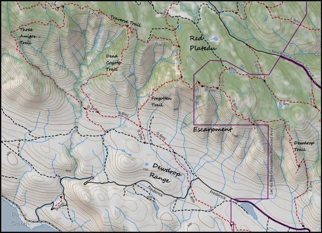
The Forgotten Trail to Dead Coyote
On a mild day in May we drove on the rough Upper Dewdrop Trail to access the Dead Coyote Trail. Using our maps and GPS, we located the Forgotten Trail and hiked to the foot of the Red Plateau Escarpment. The Forgotten Trail was the designated down route for the Dewdrop Trail. Soon after the trail was built I went in to the local Ministry of Forests Office (Outdoor Recreation Section) to copy some of the maps they had developed. The trail down the ridge was clearly marked so we hiked up the Dewdrop Trail, across the Rim Traverse and down the steep ridge. The trail was a bit sketchy so it had fallen into disuse and was hard to find from the top end. We had tried twice taking various routes down, none of which were very good. This time the goal was to find the trail from the bottom using the map and georeferenced points.
We went right to the trail and started the long, steep route up the rugged ridge to the top. We climbed 790 vertical metres (2600+ ft.) in only 2 km.

The single track was distinct and well-marked, but much of it was on loose material. There were frequent views to the Dewdrop Range below.

We had lunch at a viewpoint on the Rim Traverse Trail, then hiked west for 2 km.

The descent down the Dead Coyote Trail is more forgiving, but it still requires some care on the steep sections.

Some video clips were produced into a YouTube video, mostly featuring the Rim Traverse and the Dead Coyote Trail.
This was a hard 4 hour hiking route, but we will be back to the Rim again this year, combining the Forgotten Trail and the Dead Coyote Trail with other trails like the Rim Traverse, the Dewdrop Trail, various Red Plateau routes, and the Three Amigos Trail. There are posts on all of these routes on this website.

Doug Smith
Doug writes for Kamloops Trails, a not-for-profit (and ad free) website, offering information on trails, waterways, routes, featured spots, viewpoints, and explorations in the outdoors in the Kamloops area (and beyond).
Doug started exploring this area in 1976 and continues to follow tracks and routes wherever they lead, with the aid of map, compass, GPSr and camera. After many dead-ends, but also many discoveries, he chose to share this information.
The Kamloops Trails website has a massive number of interesting posts and would be of interest to anyone in Kamloops who enjoys the outdoors. Visit the Kamloops Trails website at: http://www.kamloopstrails.ca/
My Blog Posts