Tea with the Trolls – KamloopsTrails
At the end of September the hike for the day was up the steep Dewdrop Trail to the viewpoint (2 km), then back down the same way, but I turned onto an unofficial trail part way down which wound over to Garden of the Trolls, then back cross-country (off-trail). The Dewdrop Trail climbs from the Dewdrop Range toward the Red Plateau Escarpment, following a single track up a gully to the ridge. On this morning, there was no one else on the trail, except for a few birds. One section of the trail is quite steep.

Just after the 2 km sign is a side trail that goes down to the lookout. Three of us from the Trails Alliance improved this trail, installed the sign, and built the bench a number of years ago, supported by BC Parks.

From the viewpoint are wide views in 3 directions. A perfect spot for a shorter hike.

I hiked back down the same trail. There is one steep section that it slippery, so on the last two times coming down, I stopped to put on microspikes. This makes the descent much more enjoyable. There is a side trail about halfway down which is easy to miss, but there are some trail markers (thanks to Al). The trail goes over to Garden of the Trolls.

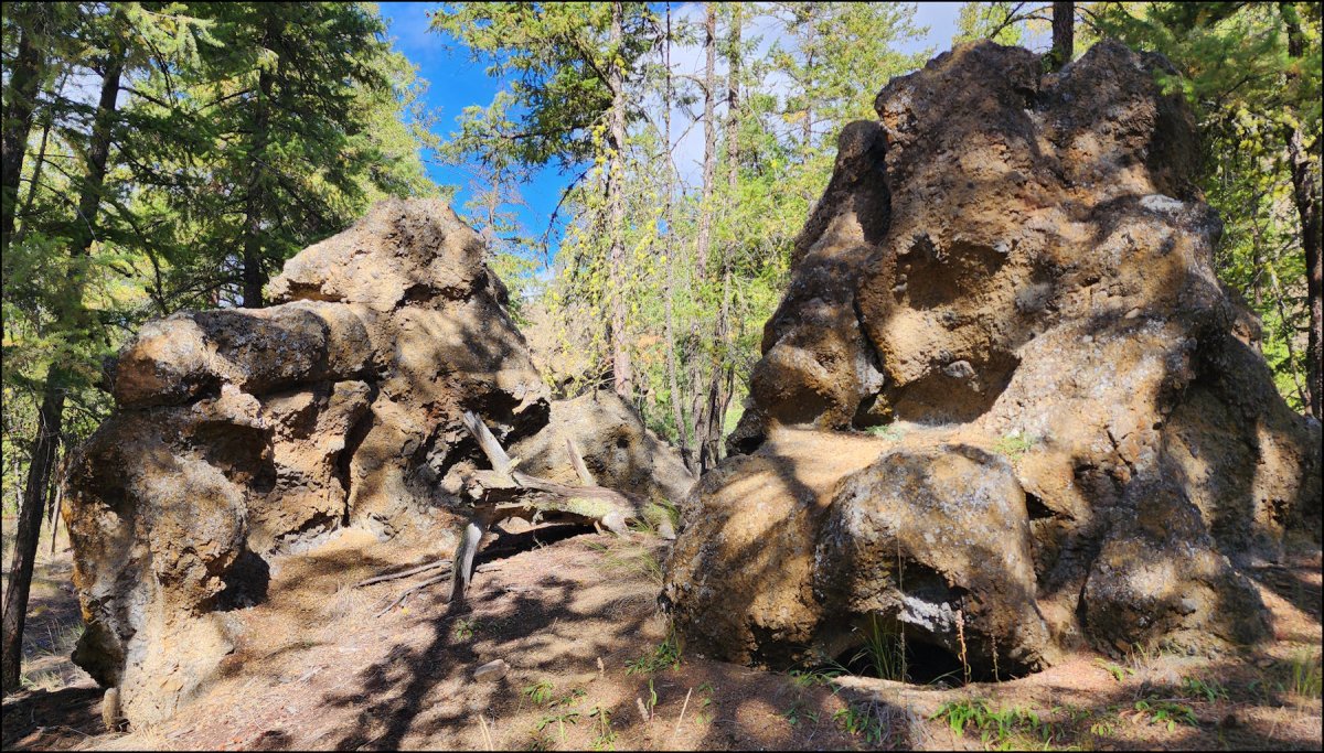
The Garden of the Trolls is an area at the foot of the Jag Hill cliffs. On the cliffs are a number of pillars, hoodoos, ragged ridges, an arch, and unusual lava flow rock features. A few dozen have broken off over thousands of years and now stand as misshapen rock sculptures in a bowl shaped area among the trees – now called Garden of the Trolls.

Between two of the monoliths is a small informal rest stop. I had tea with the trolls before heading back.

I did a circuit of the Trolls before heading back. There are trail options to return back to the Dewdrop Trail, or to follow a single track out to the Tranquille Criss Creek Road.

I chose to take a beeline back to the trailhead, winding among sagebrush and then down steeper grasslands hills to the start.

On the way down there were views of the Red Plateau Escarpment, rugged, steep, and challenging terrain.

Any cross-country route requires strong ankles, good balance, and some experience on the steeper sections. It is probably faster to return on established trails, but for a few years yet, I may continue to choose to pick my own route.
Doug Smith
Doug writes for Kamloops Trails, a not-for-profit (and ad free) website, offering information on trails, waterways, routes, featured spots, viewpoints, and explorations in the outdoors in the Kamloops area (and beyond).
Doug started exploring this area in 1976 and continues to follow tracks and routes wherever they lead, with the aid of map, compass, GPSr and camera. After many dead-ends, but also many discoveries, he chose to share this information.
The Kamloops Trails website has a massive number of interesting posts and would be of interest to anyone in Kamloops who enjoys the outdoors. Visit the Kamloops Trails website at: http://www.kamloopstrails.ca/
My Blog Posts