Snowshoeing the Walloper Creek Loop
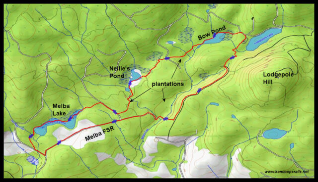
There are a number of snowshoe routes that start at Lodgepole Lake. Various shorter loops can be combined for a day in the snowy forests. A longer route has been developed over many years of exploration. It connects a series of ponds, lakes, streambeds, double tracks, and established single tracks, all in the Walloper Creek drainage area, but the route requires good navigation skills. From the Rec site parking area, we dropped down to Bow Pond.
Tracks were already set around either side of the pond. We wound along the shoreline to the far end, then climbed out through an established (but unsigned) trail through the forest up into a plantation.
 We navigated our way over to a OHV trail called Roots of all Evil as it wound through the trees on the edge of Nellie’s Pond. Melba toast is named after Nellie Melba, an operatic singer. The pond corridor can be used as a route over to Melba Lake, 0.6 km southwest.
 Nellie’s Pond is a large marshy area, a quiet wetlands retreat on the eastern side of Chuwhels Mountain.
 Using OHV tracks (mostly used by motorcyclists), we followed the Mod Squad trail to get over to a branch road, then into Melba Lake.
 We traversed the length of Melba Lake, stopping for lunch at a point halfway along the narrow, twisting lake.
 From the south end of Melba Lake we emerged onto spur roads of the Melba Forest Service Road. Snowshoeing the double tracks, with a series of turns took us down to Walloper Creek.
 We crossed the snow-covered creek and climbed through a plantation to a branch road of the Walloper Forest Service Road. This road goes north toward Lodgepole Lake.
 The afternoon sun was welcome as we finished our 9 km loop route, going to almost the end of the route, then turning onto an established single track which climbed up to the campground above.
 The whole route takes over 3 hours and will require some navigation skills to stay on track. Our snowshoe track will help, but there are more tracks out there so a GPS or an app with GPS capacity would be a good idea. We have done this route every year for a number of years, but it is a good one so we will return there again next winter.

Doug Smith
Doug writes for Kamloops Trails, a not-for-profit (and ad free) website, offering information on trails, waterways, routes, featured spots, viewpoints, and explorations in the outdoors in the Kamloops area (and beyond).
Doug started exploring this area in 1976 and continues to follow tracks and routes wherever they lead, with the aid of map, compass, GPSr and camera. After many dead-ends, but also many discoveries, he chose to share this information.
The Kamloops Trails website has a massive number of interesting posts and would be of interest to anyone in Kamloops who enjoys the outdoors. Visit the Kamloops Trails website at: http://www.kamloopstrails.ca/
My Blog Posts