Sabino Canyon – Kamloops Trails
The Santa Catalina Mountains rise above the Sonoran Desert near Tuscon. Stream-cut canyons provide access into the mountains. A narrow and winding road was built into the canyon, wide enough for only vehicle at a time and since 1978 a tram has run up the canyon for 3.8 miles with 9 stops along the way, providing access to various trailheads. At the uppermost stop the Sabino Canyon Trail starts. We hiked up and back on the trail on a warm, sunny day.
The lower slopes of the Catalina Mountains are rocky and treeless, with saguaro cactus, and other desert shorter cacti and shrubs. A network of trails climbs into the mountains. The middle elevation slopes of Mount Lemmon (9000 feet) are in the middle of this photo.
 As we gained altitude we could see the treeline at about 7000 feet, due north.
 As we rode the shuttle up the canyon, we crossed Sabino Creek a number of times. The trail continued to follow the creek with views into the narrow canyon below. We arrived at a junction area of several canyons – East Fork, West Fork, Box Camp, Palisade, Sycamore, Bear, and Lemmon. We had lunch at the side of the creek and enjoyed the riparian zone. Along the route, we stopped to take photos of wildflowers and wildlife.
Click an image for an ID:


We could see that there were weeks of exploration higher in the Santa Catalina Mountains, but for this day we returned the way we came, enjoying the rocky ridges, bluffs, canyons and Sonoran Desert vegetation around us.
 and
and
 We hiked these trails early in March when the temperatures were warm. These south-facing slopes would be hot and difficult later in the spring and summer.

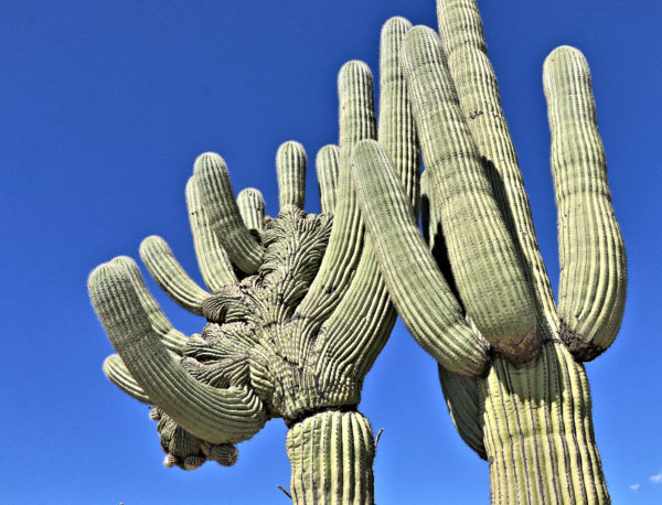
Saguaro cactus grow slowly, taking decades to grow one arm. This pair greeted us on the way back down. The one on the left is a cristate, a crested saguaro which happens 1 in 10 000 times.
 This is a hike worth doing again, starting earlier and climbing higher. The route up the West Canyon to Hutch’s Pools and back is 8.2 miles. There is also a loop route – Sabino Canyon – East Fork – Bear Canyon, a 27 km route which would take all day. There are also excellent backpacking opportunities in the Santa Catalina Mountains with Sabino Canyon as the starting point.

Doug Smith
Doug writes for Kamloops Trails, a not-for-profit (and ad free) website, offering information on trails, waterways, routes, featured spots, viewpoints, and explorations in the outdoors in the Kamloops area (and beyond).
Doug started exploring this area in 1976 and continues to follow tracks and routes wherever they lead, with the aid of map, compass, GPSr and camera. After many dead-ends, but also many discoveries, he chose to share this information.
The Kamloops Trails website has a massive number of interesting posts and would be of interest to anyone in Kamloops who enjoys the outdoors. Visit the Kamloops Trails website at: http://www.kamloopstrails.ca/
My Blog Posts