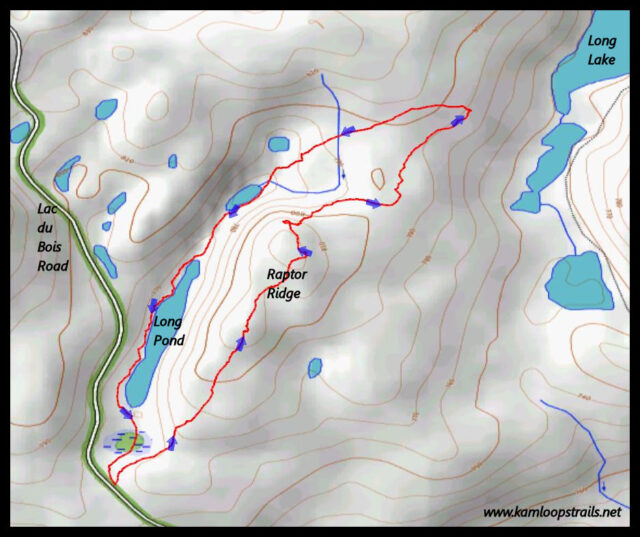
Raptor Ridge, Long Lake, and Long Pond
On the last day of fall we hiked into the Middle Grasslands, making our own route across the hills. At about the 7.75 mark on the Lac du Bois Road we parked in a small pullout, then hiked northeast to the foot of Raptor Ridge.
Raptor Ridge is a glaciated feature, a drumlin-shaped hill of glaciated materials. We hiked 1 km to the north end of the hill. On top of the hill are some tall snags and fir trees. Red-tailed hawks and other raptors sometimes perch on the branches watching over the grasslands below. The top is also a good viewpoint for hikers.
We went down the steep slope on the north end of ridge then wound through the grassland hills to a small hilltop.
 From the line of hills we hiked we had views down to the bottom of the trench where Long Lake and a string of ponds lie. Batchelor Ridge rises above the trench of the east side with Strawberry Hill wreathed in snow across the North Thompson River Valley.
 We stopped for lunch on a small hill. The line of ponds continues south toward Kamloops. The pond are filled with runoff from the surrounding hills. During spring some seep and gradual drainage runs north into McQueen Creek. In the Ice Ages, the flow of runoff would have continued south toward Kamloops.
 From the viewpoint we have a good view of Long Lake which continues north for 2 km.
 We returned by a different route contouring through low hills into a drainage that led back to the start. We hiked past the west shore of Long Pond.
 A wet area at the south end of Long Pond fills with pickleweed in summer, leaving a red ring around the shoreline. This is a scenic spot all year-round.

We finished our 4 km loop hike, having enjoyed the mild and dry weather. Snow fell the next day, blanketing the hills, turning our choices to snowshoeing for the winter.

Doug Smith
Doug writes for Kamloops Trails, a not-for-profit (and ad free) website, offering information on trails, waterways, routes, featured spots, viewpoints, and explorations in the outdoors in the Kamloops area (and beyond).
Doug started exploring this area in 1976 and continues to follow tracks and routes wherever they lead, with the aid of map, compass, GPSr and camera. After many dead-ends, but also many discoveries, he chose to share this information.
The Kamloops Trails website has a massive number of interesting posts and would be of interest to anyone in Kamloops who enjoys the outdoors. Visit the Kamloops Trails website at: http://www.kamloopstrails.ca/
My Blog Posts