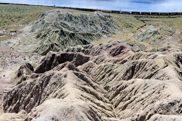
Over the Hills to Painted Bluffs
Painted Bluffs Provincial Park is an outstanding location to hike to, but its not an easy route. I have paddled there from Savona or Tobiano and i have hiked over the hills from every direction to get there each year. In early May a small group hiked over the hills from the Copper Creek Road, climbing over ridges through gullies before descending to the western corner of the park. We hiked through the bluffs and then did some scrambling up the east side to create a loop route. The route is about 8 km, with lots of climbing. We parked off the side of the Copper Creek Road about 0.7 km down from the Sabiston Creek Road junction and took a route that has no trails, but we know from much exploration. Most of these hills are open range grazing leases and licenses with no fences or signage in this area. We have met the leaseholder and talked to him about access. On foot access, respecting the land is allowed at this time.
We hiked over the sagebrush and grassland hills to a point above the Park, with a good view up Kamloops Lake.
 Our first view into Painted Bluffs was on the ridge descent, following an old faint double track to the bottom of the hills, just above the train tracks.
 When we hiked into the Bluffs last September it was 9/11 and by chance I saw 9 – 11 in the old fenceline surrounding the hydraulic mining site.
 There are no trails into the bluffs so access is by wider stream drainages. We followed the west one to the foot of the bluffs.
We can go around the bluffs by dropping lower or we can do some scrambling to go up ridges or gullies. On this day, I followed narrow sculpted ridges to get to a higher viewpoint.
 Our small (social distanced) group chose their own routes according to scrambling interests and took their own photos.
 The route up the east side was a more difficult one and it took us higher than we wanted to go with deep gullies and steep slopes on that side. We hiked up to the eastern flank of the Park.
 Our return route was back over the hills on a warm spring day. I visited Painted Bluffs 3x last year, each with a different approach. A small group did a long hike all the way from Tranquille and camped in the hills above. I did another early season hike from the Sabiston Creek Road, following old double tracks to the top of the bluffs to explore the old mine area at the top end. In late summer, I paddled over from Savona and back with a hike on a sunny day. This year I will return to Painted Bluffs by kayak again and a post will follow that adventure.
More information:
- Over the Hills to Painted Bluffs (On a Wildflower Journal)
- There are quite a few articles on this website including maps, access information, more photos, etc. Use the Search function (top right corner) to find the articles.
Doug Smith
Doug writes for Kamloops Trails, a not-for-profit (and ad free) website, offering information on trails, waterways, routes, featured spots, viewpoints, and explorations in the outdoors in the Kamloops area (and beyond).
Doug started exploring this area in 1976 and continues to follow tracks and routes wherever they lead, with the aid of map, compass, GPSr and camera. After many dead-ends, but also many discoveries, he chose to share this information.
The Kamloops Trails website has a massive number of interesting posts and would be of interest to anyone in Kamloops who enjoys the outdoors. Visit the Kamloops Trails website at: http://www.kamloopstrails.ca/
My Blog Posts
