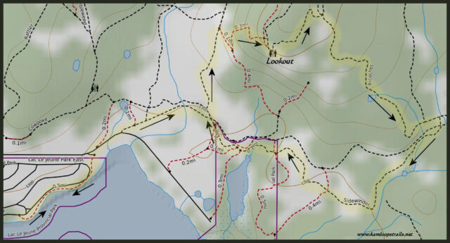
Lac le Jeune Lookout Loop
In winter we cross country ski or snowshoe the Stake Lake Trails and for a longer route, we sometimes take the Vista Trail from Stake Lake to the Lac le Jeune Lookout. In summer, we may start at Lac le Jeune and hike on the Stake Lake Trails from the south end. One of the routes we have done many times is from the campground beach to the Stake trail system, combining the Ross Moore Forest Service Road, Rustler, the Lookout Loop, and back on other trails in a loop. We often vary the combination of trails for the route back. This last time we hiked Ricochet and Sidewinder.
We know an unmarked single track that goes from Rustler to the top, so we took that shortcut to come out at the viewpoint. From the edge of the bluff we could see all of Lac le Jeune, which is about 3 km long and is surrounded by forest.
 Along the trails are a number of high country ponds and marshes in the lodgepole pine forest.
 We hiked past the junction to the Gus Johnson Trail (which goes around the lake), another option for another day of hiking.
 We spotted pinedrops (pterospora andromedea) growing just off the trail. It is the tallest of the saprophytic plants (which do not produce leaves and get their nutrients from decaying material in the ground). The small yellowish flowers are urn-shaped and hang on short branches from a tall, upright stem.
 There are several larger marshes and ponds off the end of Lac le Jeune, now surrounded by reeds, rushes, and grasses that were turning yellow.
 Our 8.7 km route took us back to the shores of Lac le Jeune. We had the opportunity for a swim at the beach or stay for lunch, but we were happy for just a 2.5 hour hike on forested trails on a late summer day.
 Many of our hikes, snowshoe outings, cross country skiing routes, bikes, and paddles over 12 months of the year are off the Lac le Jeune Road. We are lucky to have so many great options.
Directions:
- Follow the trail along the lake as it leads from the beach to the campground fence. There is a posted map there.
- Turn onto the unsigned Ross Moore Forest Service Road (its the only dirt road in the area).
- Where the Stake Lake Trails intersect the road, there are posted maps.
- If you are unfamiliar with the area, stick to the trail system, stopping to check trail signs at intersections.
- Or you can print (or take a screen shot of) the map above and take it with you.
Doug Smith
Doug writes for Kamloops Trails, a not-for-profit (and ad free) website, offering information on trails, waterways, routes, featured spots, viewpoints, and explorations in the outdoors in the Kamloops area (and beyond).
Doug started exploring this area in 1976 and continues to follow tracks and routes wherever they lead, with the aid of map, compass, GPSr and camera. After many dead-ends, but also many discoveries, he chose to share this information.
The Kamloops Trails website has a massive number of interesting posts and would be of interest to anyone in Kamloops who enjoys the outdoors. Visit the Kamloops Trails website at: http://www.kamloopstrails.ca/
My Blog Posts