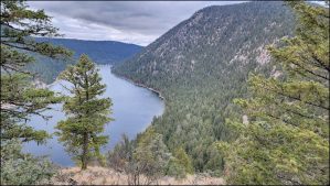
Gibraltar Rock from the West
On a grey end-of-November day I hiked from the west end of Paul Lake along the lakeshore on the Gibraltar Rock Trail.
 The trail follows the shoreline of the lake for 2 km before it starts to wind up the hill.
 For the next kilometre, it climbs the hill through the douglas fir forest to the north side of Gibraltar Rock, then winds up the bluff to the top.
 We can enjoy the views east up toward the end of Paul Lake. The beach area is on the shoreline on the left side of the photo.
 We can also look out over the west end of the lake and see the lakeshore route we hiked to get to Gibraltar Rock.
 It was an out-and-back route on this day, returning back to the trailhead for a 2 hour, 6 km hike.
 Snow will cover these trails soon and the lake will freeze over. We will be back in the spring…
Related
Doug Smith
Doug writes for Kamloops Trails, a not-for-profit (and ad free) website, offering information on trails, waterways, routes, featured spots, viewpoints, and explorations in the outdoors in the Kamloops area (and beyond).
Doug started exploring this area in 1976 and continues to follow tracks and routes wherever they lead, with the aid of map, compass, GPSr and camera. After many dead-ends, but also many discoveries, he chose to share this information.
The Kamloops Trails website has a massive number of interesting posts and would be of interest to anyone in Kamloops who enjoys the outdoors. Visit the Kamloops Trails website at: http://www.kamloopstrails.ca/
My Blog Posts