Too hot to stay cool: urban heat islands in Kamloops
Cover photo by Yaron Cohen on Unsplash
Shade is urban infrastructure
When we think about urban infrastructure, we often imagine physical assets like roads, pipes, utilities, and other facilities that require dedicated land and capital investment. These are important. Yet shade – the invisible infrastructure that mediates our relationship with the sun – is one of the most important forms of urban infrastructure. On a scorching summer day, our first instinct is simple: find shade. We step beside a wall, under the shadow of a building, or beneath a sign – anywhere that offers relief from the heat and a chance to breathe comfortably.
But not all shade is the same. The most welcoming shade comes from a tree, where birds nest and sing overhead, and the sound of flowing water may drift through the air. Gaglardi Square, which has recently reopened to the public, is a good example. A comfortable and inviting public space, it offers a pleasant environment for enjoying downtown Kamloops.
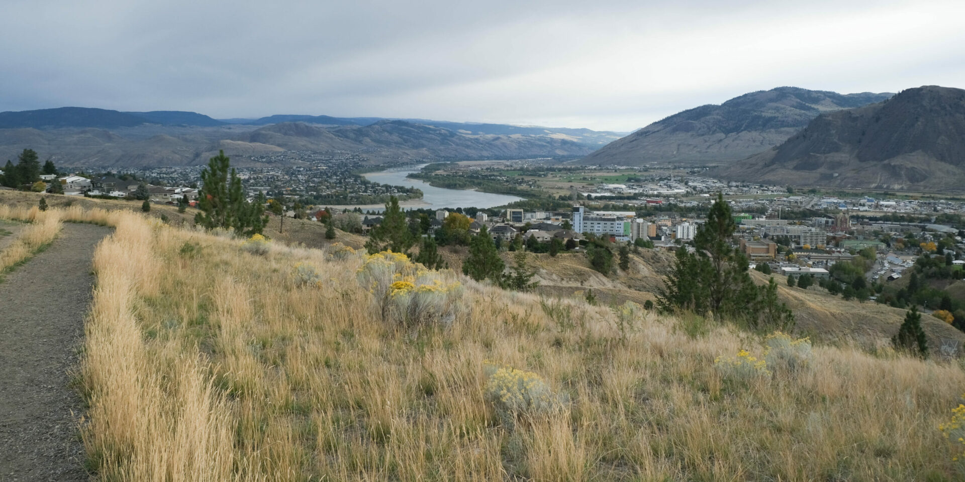
Have you ever noticed that the air feels cooler in suburban and rural areas, and warmer downtown? It is not just elevation that explains the difference, as the air may feel cooler in Dallas or Westsyde compared to downtown. Why does this happen? The answer lies in the urban fabric – the complex arrangement of streets, buildings, construction materials, vegetation, open spaces, and land uses that make up a city.
Urban surfaces matter
Urban surfaces can be divided into two categories: permeable, allowing water to pass through and soak into the ground beneath, such as soil, vegetation or bioswales, and impermeable, where water cannot infiltrate into the ground and provide a cooling effect, such as asphalt, concrete, or rooftops (1). These surfaces differ greatly in how they absorb, store, and release heat. A dark asphalt roof can reach temperatures of 74–85°C on a summer afternoon, a metal roof may reach 66–77°C, and a cool roof designed to reflect sunlight typically will only reach 43–46°C (2).
Examples of shaded pathways and permeable spaces
Source: (1): Shaded Pathway. (2). Gaglardi square, Downtown. (3). Bioswale, Brocklehurst
Large concentrations of heat-absorbing surfaces in a dense urban area without sufficient off-setting vegetation or other cooling infrastructure cause a phenomenon called an urban heat island.
Kamloops urban heat islands
Urban heat islands occur because buildings, roads, and paved surfaces absorb and trap solar energy throughout the day and release it slowly after sunset. As a result, the city becomes significantly warmer than its surrounding natural or rural area. Studies show that daytime surface temperatures in urban areas can be 10°C to 15°C higher than in nearby rural areas.
Although a high-density urban core efficiently reduces land consumption and avoids sprawl, it can also form a micro urban heat island if adequate greenery and shade are lacking. Vegetation plays a critical role in cooling environments by evapo-transpiration (plants and soil releasing moisture into the air), shading, and air circulation. Mature trees in particular give significant protection against extreme heat. In fact, during the 2021 BC heat dome event, a 5% increase in tree canopy within a 100-metre radius was found to reduce mortality risk by approximately 10%.
Shade, then, is more than a source of comfort. It is a form of urban infrastructure. Trees, green spaces, shaded sidewalks, and thoughtfully designed public places can help cool the city, reduce residents’ heat exposure and make our outdoor spaces more livable. This is an important consideration in Kamloops, which has a semi-arid climate and a reputation as one of the hottest cities in British Columbia. It is projected to be among the most exposed communities in the province to extreme heat in the future.
Kamloops’ population is also growing, creating pressure to densify, remove trees and vegetation, increase vehicle traffic, and add air conditioners, all of which can contribute to creating urban heat islands (3). During mid-summer 2015, Kamoops’ land surface temperature (not to be confused with air temperature) reached nearly 60°C. That year was the warmest year globally on record at that time, raising widespread concern and intensifying the urgency of coordinated climate action. It is regarded as a turning point in global climate awareness, including the Paris Agreement (COP21) where 195 countries, committed to work together to limit global temperature increase to 1.5°C above pre-industrial levels (4).
Comparing 2015 and 2025
In 2025 mid-summer land surface temperatures in Kamloops ranged from approximately 17.5°C to 46°C:
Kamloops’ Land Surface Temperature in 2015 and 2025
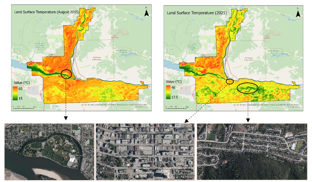
Source: Author’s analysis based on Landsat 8 data (Aug, 2015 and 2025).
GIS resources provided by Simon Fraser University.
It is clear that the downtown core, with its dense built form and many impervious surfaces, had much higher temperatures compared to other neighbourhoods. Areas with higher elevation and more vegetation such as Aberdeen and Juniper Ridge also experienced lower land surface temperatures than the areas lower in the valley and with less vegetation. McArthur Island was a major blue-green infrastructure element within the Kamloops ecosystem, playing an important role in reducing urban heat due to its vegetated areas and water-adjacent cooling effects.
How do urban heat islands affect our lives?
Urban heat islands have a range of negative impacts. They affect outdoor air quality, increase the risk of illnesses such as heat exhaustion, and can even kill. Between 1981 and 2022, there were 919 heat-related deaths in Canada. Nearly two-thirds of those deaths occurred after 2016, especially during the unprecedented extreme heat in 2021, often called the “western heat dome”(2). In British Columbia alone, there were 619 heat-related deaths between June 25 and July 1, including approximately 17 deaths in and around Kamloops (3). People did not die directly from outdoor heat exposure, but from excessive heat trapped inside buildings – 98 percent of deaths occurred indoors.
The western heat dome experience led to regulatory changes. In 2024 the BC Building Code added a requirement that at least one habitable space in every residential unit must be able to maintain a temperature of less than 26°C. Cities such as New Westminster, Vancouver, and Port Moody have also restricted landlords from prohibiting portable cooling devices in rental units (5). However, indoor temperatures can be reduced with a combination of passive and active strategies, including shading, balconies, trees and other vegetation, window design, and natural ventilation, as well as mechanical cooling systems.
Vulnerability to heat
As with all hazards, not everyone is equally vulnerable to extreme heat. Many of the 2021 heat-related casualties had pre-existing health conditions, including depression, schizophrenia, substance use disorders, diabetes and other chronic illnesses. Also, more deaths at home occurred in neighbourhoods with less green space, typically with higher building density, more paved surfaces, and fewer trees. The residents in these areas may also have lower income levels and less access to air conditioning.
Since 2021 the City of Kamloops has developed a series of heat vulnerability maps. They show that the Downtown, the North Shore, and Sahali/Southgate neighbourhoods have the greatest coping capacity (access to services and cool spaces), but also have higher vulnerability due to socio-economic factors such as education, income, and housing.
Heat Vulnerability for the City of Kamloops
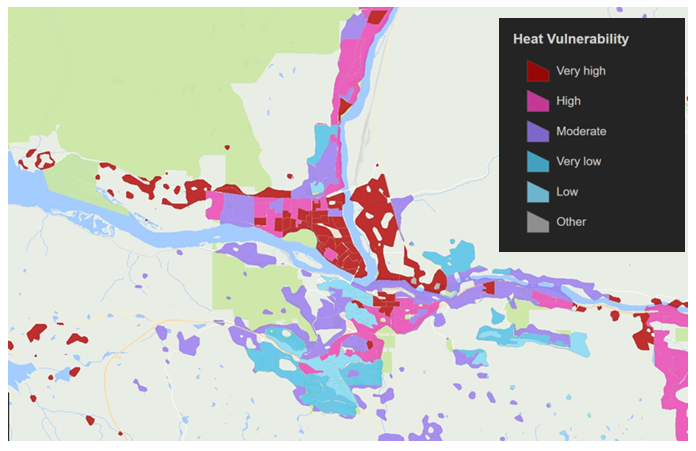
Source: City of Kamloops’ Extreme Heat Response Plan, 2024
Higher temperatures also increase water demand. A significant loss of vegetation in residential areas of Kamloops has been linked to water use restrictions on irrigating yards and gardens. This change weakens local cooling capacity and contributes to higher temperatures, potentially creating an intensifying feedback loop. This highlights the importance of planting native species that are better adapted to the dry climate, in order to provide more cooling greenery without increasing water use demand.
Humans are not the only ones affected by urban heat islands. To learn how rising urban temperatures impact birds, see the article “Urban Heat Islands Affect Birds Too!” in this newsletter.”
Responding to the threat of urban heat islands
The City of Kamloops is trying to improve the situation. The Extreme Heat Response Plan has strategies designed to increase permeable surfaces on private and public property, expand the urban tree canopy, and improve the City’s active transportation network. The updated Official Community Plan (2025) also has policies aimed at reducing the health impacts of extreme heat, particularly for vulnerable people. There are new initiatives to install seasonal water fountains and misting stations. The City’s development permit area guidelines require new developments to consider a range of design principles, including:
- demonstrate awareness of Kamloops’ semi-arid landscape context
- incorporate sheltering elements into building design
- provide weather protection at entrances and along commercial and public active frontages/sidewalks at least 1.5 metres
- minimize impervious surfaces
- use light-coloured paving materials to reduce heat absorption
- select native or drought-tolerant plant species.
City policies can support and encourage cooler choices, but reducing and responding to urban heat islands is a shared responsibility. Effective change depends not only on climate-conscious development policies and regulations, but also on the role each of us plays in creating a safer, more livable city. Homeowners can add vegetation, plant and protect trees, and create more shaded spaces? Business owners can create shade, use cooler building materials, and create more comfortable public frontages for customers and pedestrians. Together, over time, many individual actions can have a noticeable effect.
About the trees…
Boulevard trees are a very important tool for cooling urban areas. They shade sidewalks and streets, reducing pavement surface temperatures and improving pedestrian comfort. This is why Kamloops’ Tree Protection Bylaw requires the owner of a property adjacent to a boulevard (the area between the curb and the front property line) to water ‘their’ boulevard trees. Boulevard maintenance responsibilities also include weeding, mowing, and keeping the areas free of litter and waste. This is a private cost and a private and public benefit.
Kamloops has one of the lowest urban tree canopy coverage rates among major BC cities. This is largely due to its semi-arid climate, limited irrigation capacity, and natural grassland landscape. However, the City’s Urban Forestry Management Strategy has set a target of increasing the canopy cover from approximately 15% to 20%. The Tree Coupon Program is one initiative supporting this goal.
Kamloops is undergoing a transition toward increased housing development, greater urban density, and the attraction of more residents and employment opportunities. This is exemplified with a recent development proposal to create a new commercial and industrial campus, which might include AI data centre use. As the city grows, it becomes increasingly important to enhance sustainability, improve livability, and protect the life of all living species. This requires actions at every scale from preventing the creation of urban heat islands that can be associated with any potential data centres—a phenomenon referred to as the “data heat island effect“—to maintaining boulevard trees or restoring landscape that has been lost across the city since 2021.
References:
- Ayasooriya, V., Adams, M. (2024) From urban heat islands to intra-urban heat islands: Role of urban fabric in redefining microclimates of tomorrow’s compact cities, Energy & Buildings 324.
- Government of Canada (2021) Surviving the heat: The impacts of the 2021 western heat dome in Canada. Available at: https://science.gc.ca/site/science/en/blogs/science-health/surviving-heat-impacts-2021-western-heat-dome-canada?utm_source=chatgpt.com
- City of Kamloops Extreme Heat Response Plan, 2024.
- Global Temperature – Earth Indicator, available at https://science.nasa.gov/earth/explore/earth-indicators/global-temperature/
- City of Vancouver Council Report May 5, 2026.
Transition Kamloops
Transition Kamloops is a volunteer-driven, registered not-for-profit society focused on increasing local resilience and self-sufficiency in food, water, energy, culture and wellness. We emphasize a local economy, healthy ecosystems, and grassroots community building, while reducing our dependence on fossil fuels. We believe in a better way: a community that sustains life in all its diversity, strives for equality and justice and invests in the future.
Transition Kamloops recognizes that we are living on Secwépemcul’ecw—land that was never ceded to settlers, and continues to be home to vibrant Indigenous cultures, languages, and traditions. We acknowledge the impact of colonization, forced displacement, and ongoing struggles faced by Indigenous peoples. We commit to listening, learning, and building positive relationships with Indigenous communities as we work towards reconciliation.
My Blog Posts