At the “Meeting of the Waters”: Floodplain management in Kamloops
The fundamental philosophical question of whether the world is fixed or constantly changing was answered through a simple metaphor: the river. More than two thousand years ago, the Greek philosopher Heraclitus offered a powerful answer through a clear metaphor: the river. “No one can step into the same river twice,” he argued. A river is never truly the same. It is constantly shifting, reshaped by flowing water, sediment, and time. The person stepping into it is changing too. What seems permanent is, in reality, always in flux. River cities are no exception. Channels shift, banks erode, and waters periodically reclaim lands once thought to be fixed.
Despite their inherent instability, rivers and the landscapes around them have long been a source of stability for human societies. For centuries, they have served as the foundation of human civilization, supporting settlement, agriculture, and trade.
Today, these same spaces sit at the heart of urban life. Waterfronts draw investment, attract people, and carry ecological and cultural significance. Their appeal is reflected in some of the highest land values in cities. But that desirability comes with a persistent and often underestimated reality: risk.
Kamloops: A City Shaped by Water
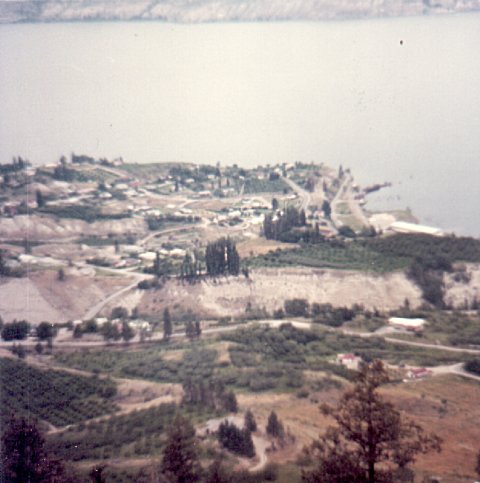
Among British Columbia’s cities, Kamloops offers a particularly clear example of a place shaped by water. Its name—meaning “Where the rivers meet”—refers to the confluence of the North and South Thompson Rivers, where the city originally formed.
From its earliest development, Kamloops has been shaped by seasonal hydrological cycles, especially spring snowmelt and rapid warming events that significantly increase river discharge. Indigenous communities in the region historically adapted their settlement patterns to these cycles, living with rather than against the rhythms of water.
Over time, following European settlements, the relationships with the river have been tested by a series of significant flood events. Let’s take a closer look at some of the major floods that have shaped Kamloops’ history:
- The first major recorded flood occurred in 1894, considered one of the most severe floods since European settlement. Water levels reached approximately between 346.2 and 347.6 meters above sea level, inundating large portions of the settlement and marking an early warning of the city’s exposure to flood risk.
- A second major flood followed in 1948, with water levels reaching approximately 345 meters on June 13. At this time, flood protection infrastructure was still limited. The result was widespread disruption: hundreds of households were evacuated, transportation and communication networks were damaged, and parts of the city were temporarily isolated. In response to repeated flooding, Kamloops began to invest in structural flood protection. The first major intervention was the construction of earthen dikes along the most susceptible sections of Kamloops riverbank, including McArthur Island, Schubert Drive, Mission Flats and parts of Brocklehurst.
- But these structures did not eliminate risk. This reality became evident in 1972, when one of the most significant floods in Kamloops’ modern history occurred. River levels reached approximately 345.2 meters, the highest recorded in the twentieth century. In this event, existing dike systems failed, approximately 600 residents were displaced, and significant disruption occurred across the city.
- A further high-water event occurred 27 years later, in 1999, with levels reaching approximately 344.7 meters (a half-metre short of 1972 measurements). Preparations for the 1999 flood began in mid-May, with sandbag supplies delivered to low-lying areas. An earthen berm was also constructed along Schubert Drive and, in mid-June, storm drains were sealed to prevent potential backup.
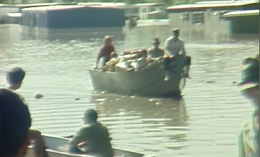
Annual high water flooding in North Kamloops – July 1972.
Source: top: Military Communications and electronics museum
– bottom: Global news, June 3, 2022
How does Kamloops manage flood plain?
Kamloops experiences annual flood risk, particularly between April and July, when snowmelt from surrounding mountains increases river flow. The City continuously tracks river levels at key points such as the Overlanders Bridge and coordinates with the BC River Forecast Centre. Public preparedness measures include sandbag distribution guidance and maintenance of drainage infrastructure such as catch basins.
However, flood management is not only about how water approaches the land; it is also about where and how land development approaches the waterfront. The zone where these forces interact—sometimes in conflict and sometimes in balance—is the floodplain. A floodplain is a low-lying area near a river or watercourse that can be flooded during high water events, even if there are dikes or other protections. In Kamloops, floodplains are defined based on how high the land sits compared to expected flood levels. The City estimates a designated flood level, usually based on a 200-year flood. A 200-year flood does not mean it happens once every 200 years. It means there is a 1 in 200 chance (0.5%) of that level of flooding occurring in any given year. To keep buildings safe, the City set a flood construction level by adding extra height, called freeboard, on top of this flood level. This means living spaces must be built above this safe elevation, while lower areas are typically used for things like parking or storage. As shown in the figure below, In Kamloops, the floodplain covers an area of about 6,500 hectares (including water area), about 1,900 ha of which is Kamloops airport and its surrounding agricultural lands.
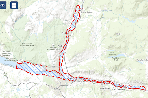
Kamloops Floodplain area
Source: City of Kamloops Open Access Map
Official Community Plan’s hazard land policies identify floodplains as high-risk areas. Habitable structures are prohibited below the 200-year flood elevation, enforced through restrictive covenants applied to new subdivisions and residential developments, including carriage houses, garden suites, and multi-unit housing.
Across British Columbia, municipalities such as Quesnel, Armstrong, Nelson, Courtenay, Surrey, White Rock, Campbell River, and the District of North Vancouver use Development Permit Areas to regulate flood hazard zones which may impose conditions such as building setbacks, elevation requirements, and design standards intended to reduce exposure to flooding and shoreline erosion.
Given the dynamic and changing nature of floodplains, ongoing monitoring and regular updates to floodplain mapping are essential. In Kamloops, efforts have been made to strengthen the floodplain regulations through the adoption of the updated Official Community Plan 2025. A draft Flood Hazard Development Permit Area was proposed to expand floodplain regulations beyond residential land uses to include commercial, industrial, and institutional development along key water bodies such as the Thompson River, Kamloops Lake, and Peterson Creek.
This proposal would have required all development to meet minimum flood construction levels and comply with setback requirements. However, concerns from representatives of North Shore Business improvement Area and Home Builders Association emerged regarding its potential impact on future developments along Tranquille Corridor and increase costs and slow development processes. The council decided to defer the proposal and did not adopt it, pending more detailed engagement with affected groups.
Looking from land to water goes beyond the building and engineering infrastructure. Instead of trying to fully contain water, cities are learning to live with it. This means restoring natural systems that can temporarily hold floodwaters and reduce peak flows. A key part of this shift is the protection and restoration of riparian areas; the vegetated zones along rivers and streams. In Kamloops, if you want to change soil, plants, buildings, or services during subdivision within 30 metres of a stream that supports fish habitat, you must follow the Development Permit guidelines. These regulations are designed to protect sensitive shoreline environments and maintain their natural function in stabilizing banks, filtering runoff, and reducing erosion.
Green infrastructure tools—such as wetlands and mini forests, tree-lined streets and parks, bioswales and rain gardens, and permeable pavements—play an important role in restoring natural hydrological systems by allowing rainfall to be absorbed where it lands, rather than being rapidly diverted into drainage systems. The Official Community Plan encourages on-site stormwater management through the integration of these nature-based solutions into site design. The City of Kamloops’ Green Infrastructure Research (2022) also highlights several public projects—such as those on Fleetwood Avenue, Richmond Avenue, and the Dufferin Wetland—that have demonstrated positive impacts in reducing localized flooding. Additional initiatives have been implemented in the Brocklehurst and North Shore neighbourhoods, where flat terrain and limited stormwater piping make these areas particularly well-suited for green infrastructure intervention. The City’s Community Climate Action Plan includes measures such as updating street standards and landscape guidelines to incorporate street trees, adequate soil volumes, and other green infrastructure techniques that promote rainwater retention. According to the implementation report, these initiatives are respectively planned for initiation and currently on track (6). Official Community Plan’s land use policy also encourages new residential projects to incorporate water-sensitive plans. This includes landscaping and site design strategies that help manage surface water—such as using flood-tolerant vegetation and features that slow, store, or redirect runoff, while still enhancing livability and visual quality in waterfront areas.
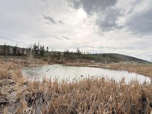
Dufferin wetland
The Green Shores program, led by the Stewardship Centre for British Columbia (SCBC), promotes nature-based approaches to shoreline management. For property owners along Kamloops Lake, it offers guidance (Green Shores for Homes) on using natural solutions to reduce erosion and flood risk and improve shoreline stability. It can also help align projects with BC regulatory expectations, which may make permitting smoother and improve eligibility for external funding by demonstrating environmentally responsible design.
The floodplain is not a fixed boundary on a map, but a living system shaped by water and uncertainty. Delaying the implementation of floodplain hazard development permit areas does not reduce the risk—it only postpones the need to confront it. These measures are not obstacles to growth; they are essential to ensuring that development is safe, resilient, and grounded in the realities of the land. At the same time, implementation of nature-based solutions brings a deeper commitment to living with water. Hopefully, the updated street and landscape design guidelines, along with the updated floodplain regulations will help the city move proactively with its water flow.
Transition Kamloops
Transition Kamloops is a volunteer-driven, registered not-for-profit society focused on increasing local resilience and self-sufficiency in food, water, energy, culture and wellness. We emphasize a local economy, healthy ecosystems, and grassroots community building, while reducing our dependence on fossil fuels. We believe in a better way: a community that sustains life in all its diversity, strives for equality and justice and invests in the future.
Transition Kamloops recognizes that we are living on Secwépemcul’ecw—land that was never ceded to settlers, and continues to be home to vibrant Indigenous cultures, languages, and traditions. We acknowledge the impact of colonization, forced displacement, and ongoing struggles faced by Indigenous peoples. We commit to listening, learning, and building positive relationships with Indigenous communities as we work towards reconciliation.
My Blog Posts